http://wenatcheeoutdoors.org/2018/07/30/spider-meadows/
Spider Meadows had been on my bucket list for too many years. Finally a date opened to tick it off and I texted my friend, Mandy, who agreed to join me. I recommended she bring her big camera and I would bring mine.
We started off at a busy trail-head with lines of cars. About 10 creek crossings and a lot of conversation later, we entered the meadows. We were greeted by the loud whistle of a Marmot sitting on the rocky outcrop at the start of the meadows. When you hear marmots whistle you know you are in the high mountains.
We found a good lunch spot and pulled out our cameras to capture the beauty surrounding us. Mandy understands cameras better than me and she gave me pointers on how to use the camera settings more appropriately to capture both the mountains and wildflowers. The pictures in this post are from that seminar.
We stayed in the meadows for over an hour taking in the craggy peaks and colorful flowers. Eventually it was time to say goodbye to this sliver of paradise and head down.
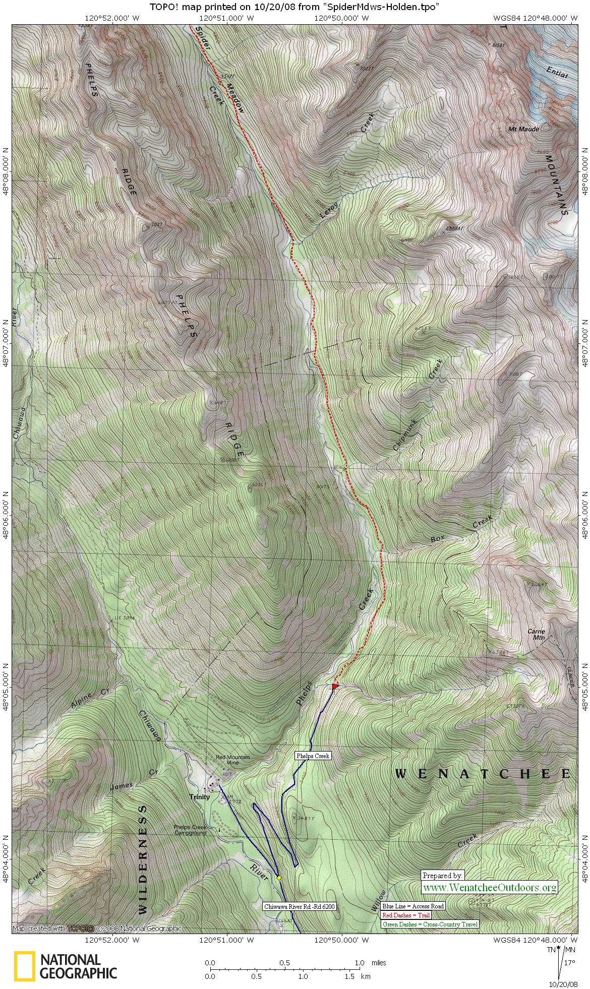
Access. Follow Highway 2 to Coles Corner, then drive 4.4 miles on Highway 207 past Lake Wenatchee State Park to a bridge crossing the Wenatchee River. Shortly past the bridge, leave Highway 207 by staying right at a fork and then veering right again at the next fork onto the Chiwawa Loop Road. About 5.75 miles from Coles Corner, the Chiwawa Valley Road branches left. Turn left and follow the road 2.7 miles to a bridge across the Chiwawa River. Cross the river and, about 0.3 miles later, curve left (remain on the paved road). The paved road becomes State Highway 3, which is also called the Chiwawa River Road. Follow this in a northwesterly direction. In eight miles the road turns to gravel, then in another 10.75 miles (at a prominent fork), veer right onto the Phelps Creek Road. Drive steeply uphill on rough road for 2.4 miles until the road ends at the trailhead (elevation 3,500 feet).
Trip Instructions. From the trailhead follow the Phelps Creek Trail, which is an old mining road. In 0.25 miles pass the Carne Mountain Trail, branching off to the right. Enter the Glacier Peak Wilderness at 2.5 miles. At 3.4 miles, cross Leroy Creek, which is likely to get your feet wet if you’re hiking in early season. A climber’s trail heads up the north side of Leroy Creek and leads to a high camp for ascending Seven Finger Jack, but you’ll keep walking up the gentler Phelps Creek drainage. A mile beyond Leroy, the pitch of the trail steepens. After 5 miles, emerge from the trees and enter Spider Meadows (elev. 4750 ft). If you want to explore further into the meadows, hike up the trail in the middle of the meadows, cross a side stream at 5.5 miles, climb through a cluster of fir trees, and enter the upper meadow.
Elevation Gain: 1,250 feet
Fitness: 1-2
Skill: 1
Permits: Northwest Forest Pass required at the trailhead.
Not allowed: Motorized vehicles and mountain bikes are verboten.
Allowed. Dogs and horses are OK for the walk into Spider Meadows. Horses are not allowed on the last two miles of the hike leading to Spider Gap.
Trip Reporter: Sarah Shaffer on 7/15/18
Leave It Better Than You Found It. This should be every outdoor user’s goal. Pick up trash left by others, pull some noxious weeds along your route, throw branches over unwanted spur trails, don’t ride or walk wet trails when you’re leaving ruts/footprints deeper than ¼ inch…
Disclaimer. Treat this information as recommendations, not gospel. Conditions change, and those contributing these reports are volunteers–they may make mistakes or not know all the issues affecting a route. You are still completely responsible for your decisions, your actions, and your safety. If you can’t live with that, you are prohibited from using our information.
